
Flooding on Hilton Head Island: King Tides and Flooded Roads
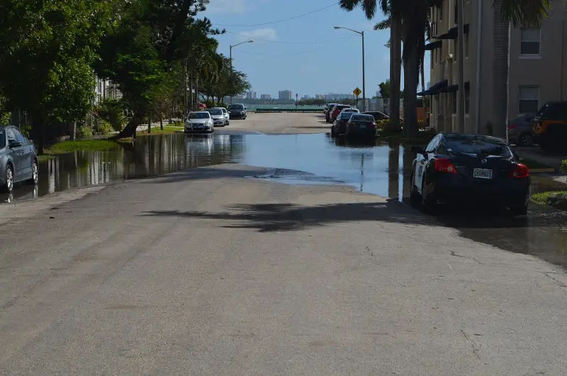
Hilton Head flooding is mostly tidal: a few times a year a king tide, sometimes helped by an onshore wind, pushes water over low roads and marsh edges around high tide. Heavy summer rain and the occasional tropical storm do the rest.
King Tides on Hilton Head
Tides on Hilton Head already rise and fall 6 to 8 feet twice a day. A king tide is the popular name for the highest of them, which come when a new or full moon lines up with the moon’s closest pass to the earth. That happens about six to eight times a year. Add a steady wind blowing onshore and the water climbs higher still: in early October 2025 the Harvest Moon king tide arrived with a persistent onshore wind, and the weather service warned the coast of possible major flooding.
On a calm, sunny day a king tide can still put salt water across a low road beside the marsh, fill storm drains and cover low spots by the creeks, then drain away as the tide falls. Look up the dates in advance on the Hilton Head tide chart: the highest predicted tides of the month are the ones to watch.
Flooded Roads: Turn Around, Don’t Drown
Don’t drive through standing water. More people drown in their cars than anywhere else in a flood, and you can’t see whether the road under the water is still there.
Don’t walk through moving water. Six inches of it can knock you off your feet.
Never drive around a barrier. The road or bridge beyond it may be washed out.
Slow down near flooded roads. Every car that pushes through sends a wake into the homes and yards beside it.
Rain floods roads here too. August and September are the wettest months, and a slow tropical storm can drop more rain than the drainage can carry: during Tropical Storm Debby in August 2024, Dunnagans Alley, the road that runs alongside US 278, went under water and officials asked people to stay off the roads. See Hilton Head weather for rainfall by month.
Coastal Flood Advisories and Warnings
9.5 feet at Fort Pulaski
The flood stage at which the National Weather Service issues a coastal flood advisory for the area.
10 feet
Flooding reaches some buildings and roads near the water.
10.5 feet
The top of the weather service’s scale for this gauge: serious flooding along the coast.
The National Weather Service office in Charleston watches the tide gauge at Fort Pulaski, at the mouth of the Savannah River about 16 miles south of the island, and warns the Hilton Head area when a high tide is forecast to reach its flood stages. The levels are measured above the average low tide, so a 10-foot reading is about two and a half feet above a normal high tide. On November 23, 2018, a king tide and a strong northeast wind pushed the Fort Pulaski gauge to 10.25 feet, the area’s first major coastal flood since Irma the year before.
When a storm is coming, local radio carries the weather service and emergency updates: WYKZ 98.7 FM, WGCO 98.3 FM and WWVV 106.9 FM.
Storm Surge: When Flooding Comes With a Storm
The worst flooding comes with tropical storms, when wind drives the sea itself onshore. In 2016 Hurricane Matthew’s surge ran three to five feet above the normal tides in Beaufort County. In September 2017 Tropical Storm Irma passed far offshore, yet its surge still flooded about 203 buildings on the island, hardest in South Beach, Point Comfort, Burkes Beach and Hilton Head Plantation.
If an evacuation is ordered, leave. The season, the history and how evacuation works are on Hilton Head hurricanes.
Hilton Head Flood Zones and Flood Insurance
| Flood zone | What it means |
|---|---|
| X | Low risk |
| Shaded X | Moderate risk: a 0.2% chance of flooding in any year |
| AE | High risk: a 1% chance of flooding in any year |
| VE | High risk, plus storm waves on the coast |
| AO | Shallow flooding |
Hilton Head is a low, flat barrier island, and FEMA’s flood maps mark its low-lying areas as flood zones. If you own a home here or are buying one, look up the address on the Town of Hilton Head Island’s Flood Hazard Zone Search, or call the Town’s floodplain administrator on (843) 341-4687 about maps, elevation certificates and past flooding.
Homeowners insurance doesn’t cover floods. Flood cover is a separate policy, and you don’t need a mortgage or a high-risk zone to buy one.
Every Town resident can buy it through the National Flood Insurance Program, and renters can insure their belongings.
A 25% discount: the Town’s floodplain work earns a Class 5 rating in FEMA’s Community Rating System, which takes 25% off federal flood policies on the island.
Shopping for a house? See Hilton Head real estate.
Frequently Asked Questions
Does Hilton Head flood?
Low roads and yards near the marsh flood briefly at the highest tides of the year, and heavy rain or a tropical storm can flood more widely. Most of the time, and on most of the island, the roads are dry.
What is a king tide?
The popular name for the highest tides of the year, when a new or full moon coincides with the moon’s closest approach to the earth. It happens about six to eight times a year.
When do king tides happen on Hilton Head?
Around the new and full moons that fall closest to the moon’s nearest approach, about six to eight times a year. They flood most when an onshore wind piles extra water on the coast. The tide chart shows the highest predicted tides each month.
Is it safe to drive through flooded roads on Hilton Head?
No. Turn around: you can’t see how deep the water is or whether the road is still there, more people drown in cars than anywhere else in a flood, and six inches of moving water can knock a person down.
How do I find my flood zone on Hilton Head?
Use the Town of Hilton Head Island’s Flood Hazard Zone Search, or call the Town’s floodplain administrator on (843) 341-4687.
Is flood insurance cheaper on Hilton Head?
Federal flood policies on the island get a 25% discount, because the Town holds a Class 5 rating in FEMA’s Community Rating System.
Local guides like this come standard for Guests of Partner Properties — one small part of what a Partner Property gives every guest.
Book Partner Properties